1
The 'Bangar' region in the Northern Plains of India is characterized by:
By Priya Sharma · Static GK Expert
A comprehensive collection of 20 high-quality MCQ questions covering the physiographic features, formation, and distribution of deserts and plains in the Indian subcontinent.
The 'Bangar' region in the Northern Plains of India is characterized by:
Which of the following semi-arid regions is located between the Aravalli range and the Thar Desert?
The 'Terai' region of the Northern Plains is best described as:
The Luni river, which originates in the Aravallis, vanishes into which of the following regions?
Which of the following is the largest alluvial plain in India?
The 'Bhabar' belt is characterized by which of the following features?
What is the local name for the fertile floodplains in the Punjab region?
Which desert is characterized by the presence of 'Playas' (short-lived lakes)?
The 'Doab' region in the Northern Plains refers to:
Which state has the largest area covered by the Thar Desert?
The 'Rohi' plain is a fertile tract found in which region?
The movement of sand dunes in the Thar Desert is known as:
Which mountain range acts as the eastern boundary of the Thar Desert?
The Northern Plains of India are essentially a result of:
What is the term for the seasonal streams that cause soil erosion in the Hoshiarpur district of Punjab?
The Thar Desert receives very low rainfall primarily because:
Which soil type is most prevalent in the Northern Plains of India?
Which of the following is a characteristic feature of the desert region of India?
The 'Bhabar' belt is widest in which region?
The 'Khadar' plains are rejuvenated every year by:
Which specific geological formation in the Northern Plains is composed of old alluvium and contains calcareous deposits locally known as 'kankars'?
The 'Bet' lands in the Punjab plains refer to which type of depositional feature?
Which of the following is the most prominent feature of the 'Bhabar' belt that makes it unsuitable for agriculture?
The 'Thar Desert' in India is considered a part of which larger desert system?
In the context of the Northern Plains, what is the term used for the marshy and swampy region formed by the resurgence of streams in the south of the Bhabar belt?
Which mountain pass/range is responsible for the rain-shadow effect that contributes to the aridity of the Thar Desert?
The Northern Plains of India are divided into three sections; which river system forms the 'Punjab Plains'?
What is the primary reason for the absence of large-scale drainage systems in the western parts of the Thar Desert?
Which of the following terms describes the crescent-shaped sand dunes found extensively in the Thar Desert?
The 'Khadar' plains are characterized by which of the following?
Which of the following regions is an example of a structural plain formed by the aggradational activities of the rivers?
What are 'Dhaya' plains in the context of the Punjab-Haryana region?
The Thar Desert is largely located in the state of Rajasthan, but it extends into which other Indian state?
Which term describes the land between two rivers in the Northern Plains?
What is the name of the salt-water lake located in the Thar Desert region of Rajasthan?
Which soil type is extensively found in the Thar Desert due to the arid conditions?
Which of the following is the largest 'Doab' in the Punjab plains?
The Northern Plains reach their maximum width in which direction?
Which landscape feature in the Thar Desert is caused by the deposition of sand in the shape of long ridges?
What is the common name for the seasonal streams that disappear in the sandy plains of the Thar Desert?
The 'Bhabar' region, characterized by high porosity and pebble-strewn landscape, is located at the foot of which mountain range?
Which of the following terms describes the undulating sandy plains of the Thar Desert covered with longitudinal sand dunes?
The 'Khadar' soil is highly productive because it is replenished every year by:
In the context of the Thar Desert, what is the significance of the 'Luni' River?
Which region of the Northern Plains is synonymous with 'old alluvium' and is situated above the flood limits of the rivers?
The 'Reh' or 'Kallar' lands in the Northern Plains refer to areas affected by:
Which of the following desert features is a salt-lake or 'playa' found in the Thar Desert?
The 'Bist Doab' in Punjab is the land lying between which two rivers?
Which of the following statements about the Thar Desert's rainfall pattern is correct?
The 'Terai' region is characterized by:
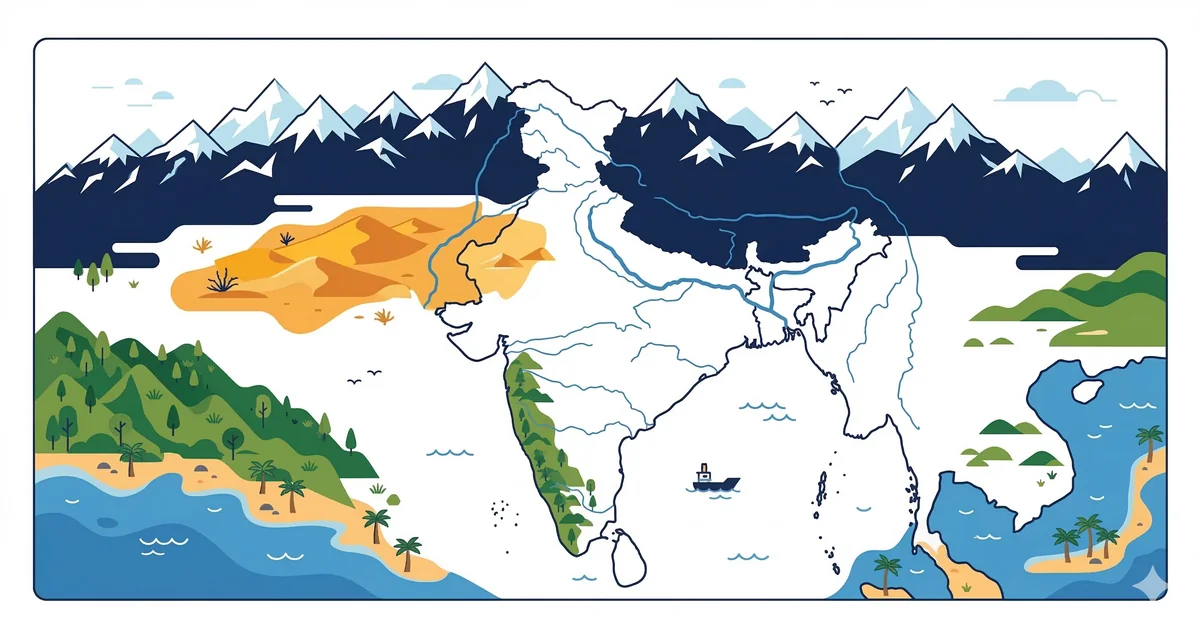
The Thar Desert, also known as the Great Indian Desert, is a significant arid region located in the northwestern part of the Indian subcontinent. It covers an area of approximately 200,000 sq. km, primarily spread across the state of Rajasthan, with parts extending into Haryana, Punjab, and Gujarat.
The Northern Plains are formed by the interplay of three major river systems: the Indus, the Ganga, and the Brahmaputra. Covering an area of roughly 7 lakh sq. km, these plains are among the most fertile and densely populated regions globally.
The Northern Plains are divided into four distinct belts from north to south:
Deserts and plains MCQ questions cover India's major physiographic divisions, with focus on the Thar Desert, the Great Plains of India (Indo-Gangetic Plain), and the Deccan Plateau. These are tested in UPSC Prelims physical geography section, SSC CGL GA, and all State PSC geography papers.
The Thar Desert (Great Indian Desert) in Rajasthan and parts of Gujarat, Punjab, and Haryana is the world's 7th largest desert and Asia's largest hot desert. It covers ~200,000 sq km. Jaisalmer district has the largest area within the Thar. The Indira Gandhi Canal (Rajasthan Canal) is the world's longest irrigation canal (~650 km main channel + 9,060 km distributaries) and has transformed parts of the Thar into agricultural land.
The Northern Plains (Indo-Gangetic Plain) are formed by alluvial deposits from the Indus, Ganga, and Brahmaputra river systems. They stretch ~2,400 km from Punjab in the west to Assam in the east and cover about 7 lakh sq km. The plain is divided into: Punjab-Haryana Plains (Indus system), Ganga Plain (largest), and Brahmaputra Plain (Assam). The Ganga Plain is further divided into Upper Ganga Plain (UP), Middle Ganga Plain (Bihar), and Lower Ganga Plain (West Bengal).
The Thar Desert (Great Indian Desert) in Rajasthan is Asia's largest hot desert and the world's 7th largest desert, covering ~200,000 sq km.
Doab (from Persian: 'two waters') refers to the land between two rivers. The Ganga-Yamuna Doab between the Ganga and Yamuna rivers is the most fertile agricultural region in India, covering western UP and parts of Uttarakhand.
About the Author
Indian History · Geography · Polity & Economy Specialist
With 8+ years of teaching static GK for competitive exams, Priya has helped thousands of students master the foundational subjects that appear year after year in UPSC, SSC, and Railway exams. She focuses on making history, geography, and polity approachable through well-structured MCQs and memorable explanations.