1
Which range of the Himalayas is most famous for its hill stations like Shimla, Mussoorie, and Nainital?
By Priya Sharma · Static GK Expert
A comprehensive collection of 20 high-quality objective questions covering the physiographic regions of India, including mountains, plains, plateaus, and coastal areas.
Which range of the Himalayas is most famous for its hill stations like Shimla, Mussoorie, and Nainital?
The 'Dun' valleys are located between which two Himalayan ranges?
Which is the highest peak in the Eastern Ghats?
The 'Bhangar' region of the Northern Plains is characterized by:
Which of the following passes connects the Srinagar valley with Leh?
The Narmada and Tapti rivers flow through which type of geological structure?
Which Indian state has the longest coastline?
The 'Patkai', 'Naga', and 'Lushai' hills are collectively known as:
Which of the following plateaus is known as the 'Storehouse of Minerals' in India?
The Coromandel Coast of India is located between which two states/areas?
Which group of islands in India is of coral origin?
Which hill range separates the Malwa Plateau from the Deccan Plateau?
The 'Bhabar' belt is a narrow strip of land found at the:
Which peak is located in the Zanskar range?
The 'Palghat Gap' is located between which two mountain ranges?
Which is the only major river that flows through the Thar Desert?
The 'Central Highlands' in India are bounded to the West by:
Which of the following is the highest peak of the Western Ghats?
The 'Ten Degree Channel' separates which of the following?
Which of these regions is also known as the 'Sahyadris'?
Which geological division of India is considered the oldest and most stable landmass?
The Karewa formations, famous for saffron cultivation, are located in which Himalayan region?
Which mountain range acts as a watershed between the Arabian Sea and the Bay of Bengal drainage systems?
The northern part of the Western Coast of India, from Daman to Goa, is known as:
Which pass is situated at the southern end of the Nilgiri Hills and serves as a major trade route between Kerala and Tamil Nadu?
The 'Terai' region is characterized by which of the following features?
Which peaks are commonly referred to as the 'Garjat Hills'?
The Andaman and Nicobar Islands are separated by which of the following?
Which plateau is often referred to as the 'Mineral Heartland of India' due to its immense reserves of coal, iron ore, and manganese?
The Aravalli range acts as a climatic divide for which region?
Which of the following mountain peaks is not located in the Himalayas?
Which river valley separates the Ladakh range from the Zanskar range?
The 'Khadar' region of the Northern Plains represents:
Which hill station is situated in the Cardamom Hills?
The 'Deccan Trap' is primarily formed by which type of volcanic activity?
Which range connects the Satpura and the Vindhya mountains?
What is the name of the narrow gap between the Andaman and Nicobar islands?
Which state has the largest share of the Deccan Plateau in terms of area?
The 'Kailash' range is considered a part of which of the following?
Where do the Eastern and Western Ghats meet?
The 'Indus-Sutlej' interfluve is located in which division of the Himalayas?
Which of the following passes is known as the gateway connecting India with Tibet, situated in the Kumaon region?
The 'Palk Strait' lies between which of the following regions?
Which mountain range is geographically the oldest fold mountain range in India?
The 'Barren Island', the only active volcano in India, is located in which of the following groups?
Which region of the Northern Plains is formed by the deposition of new alluvium every year by floods?
The 'Maikala Range' acts as a connecting link between which two mountain systems?
Which plateau is often described as the 'Roof of the World' (specifically the Indian extension)?
The 'Konkan Coast' extends between which two locations?
Which of the following mountain peaks is also known as 'Godwin-Austen'?
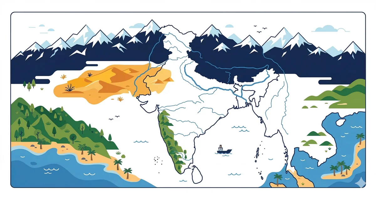
India exhibits immense physical diversity, broadly categorized into six physiographic regions. Understanding these is essential for UPSC, SSC, and other competitive examinations.
The Himalayas represent the world’s youngest fold mountains, stretching approximately 2,400 km from the Indus in the west to the Brahmaputra in the east.
Formed by the alluvial deposits of the Indus, Ganga, and Brahmaputra river systems, this is the most fertile region in India.
This is the oldest landmass of India, representing a part of the ancient Gondwanaland.
India’s coastline extends over 7,516.6 km.
Located to the west of the Aravalli Range, this region is characterized by arid climate and low vegetation.
India has two major island groups:
Physical divisions of India MCQ is a foundational topic tested in every competitive exam. India is divided into six major physical divisions: the Northern Mountains (Himalayas), the Northern Plains, the Peninsular Plateau, the Coastal Plains, the Indian Desert (Thar), and the Islands. UPSC Prelims tests these in depth; SSC CGL and RRB NTPC ask simpler factual questions about each division.
The Himalayas form the northern boundary of India and are the world's highest mountain range. They are geologically young fold mountains formed by the collision of the Indian and Eurasian plates (Himalayan orogeny, ~50 million years ago). The Himalayas consist of three parallel ranges: Himadri (Great/Inner Himalayas — highest, continuous, avg elevation 6,000 m), Himachal (Lesser Himalayas — Pir Panjal, Dhauladhar, Mahabharat), and Shiwaliks (Outer Himalayas — foothills, 900–1,100 m).
The Trans-Himalayas lie north of the main Himalayan range and include the Karakoram Range (K2 — 8,611 m, second highest in the world), Ladakh Range, and Zaskar Range. K2 is in Pakistan-administered territory; Kangchenjunga (8,586 m) in Sikkim is the third highest globally and the highest peak in India. The Indus, Sutlej, and Brahmaputra are antecedent rivers — they predate the Himalayas and cut through the ranges as the mountains rose around them.
Northern Mountains (Himalayas), Northern Plains (Indo-Gangetic Plain), Peninsular Plateau (Deccan), Coastal Plains, Indian Desert (Thar), and Islands (Andaman & Nicobar, Lakshadweep).
Nanda Devi (7,816 m) in Uttarakhand is the highest peak entirely within India. Kangchenjunga (8,586 m) in Sikkim is higher but is on the India-Nepal border.
About the Author
Indian History · Geography · Polity & Economy Specialist
With 8+ years of teaching static GK for competitive exams, Priya has helped thousands of students master the foundational subjects that appear year after year in UPSC, SSC, and Railway exams. She focuses on making history, geography, and polity approachable through well-structured MCQs and memorable explanations.